The major changes that affected the Romanian political life nowadays and those that we can figure for a future integration into the European Community structures, require a deep research of the mechanisms which control the dynamic of the Iasi territory and its position in the regional spatial systems. Starting from some anterior researches [5, 6] this article is the result of a detailed analysis of the spatial evolution of Iasi City, the old capital of Moldavia, today a regional metropolis in the northeastern of Romania. The study finality was to delimitate new periods in the evolution of the phenomenon, based on the importance of the factors that structure the urban and regional territory, to emphasize the territorial changes since 1990 and the tendencies that orientate the future evolution of the urban landscape.
The phases of the spatial evolution of Iasi City. The urban evolution since the apparition until 1564 is under the direct influence of the natural and economic factors. The geographical situation (crossing place on the Bahlui river, in a geomorphological contact area, offering multiple ways of a complementary natural resources' valorization) and the settlement's site (the strategic and economic advantages of the inferior terrace of Bahlui, dry and stable; the importance of a sheltered climate for the agriculture, the vegetal resources valorized as food sources, construction materials and basis for the animal breeding; water resources required to supply the city population and for fishing) constituted the basis for the foundation of the settlement, favoring its spatial and economic evolution. Step by step, the natural factors are replaced by the economic and politico-administrative factors in the structure and the dynamic of the urban landscape: Iasi has not accidentally emerged at the intersection of two important economic European axes (a branch of the road which connected the Italian colonies from the northern seashore of the Black Sea with Kamenitse and Lviv; the "Bahlui road" to the Transylvanian cities), fact that will affect the evolution of the settlement as a burg, royal residence and later on as a capital.
The city develops spontaneously, stimulated by the commercial and manufactures progress and by the immigration of many foreign merchants, but its development is still conditioned by the natural factors. Iasi expands on the dry and stable terrains of the inferior Bahlui's terrace, along the two commercial axes, so that , in 1564, it had o surface around 71 ha.
Iasi during the late Middle Age (1564 - 1774). The new political status of the city, as capital of Moldavia (1564), generates an important demographical and economic increase. The demographical tides attracted by the new capital, and the increase of the labour specialization reflects on the spatial growth and the socio-professional specialization. Thus the normal evolution of the city is affected by the negative influence of some factors as: the relationships of feudal production, which establish the monastery property on the surrounding areas of Iasi, the maintenance of the feudal privileges and of an exaggerate fiscally regime; many invasions associated with fires and epidemics; the lack of urban utilities, etc.
The city surpasses the inferior terrace limits and the Bahlui river, integrating three villages independently developed (Tatarasi, Rufeni, Piticani) and by the appearance of a new commercial axis and of the Munteni village in the northern part of the settlement. In the surroundings there were built fortified monasteries and a new urban nucleus is founded by a German colony in Pacurari.
Iasi, since the beginning of the Modern Age till the lost of the capital status (1774 - 1862). Since the Kuciuk - Kainargi peace (1774) the urban Iasi life is marked by historical, political and social events with important influence on the spatial evolution: the maintenance of the feudal relationships generates social uprisings and a progressive opening to the modernity and the capitalist relations. The modernity elements penetrate into all the domains of the urban life: administration, school and economy. The first factories and a local bourgeoisie appear, the commercial relationships with the Occident multiply, the first prestigious educational institutions develop, the urban life ameliorates and Iasi becomes a real economic, political and cultural metropolis.
There is an emphasis of the tentacle expanding of Iasi, based on the increasing of the roads' importance since Iasi became a commercial metropolis. In the northern part of Iasi a rich district achieves the individualization of Munteni village, while the rural immigration supplies the chaotic outskirts growth which swallow burgs and villages from the neighborhood: Nicolina, Rohatca Salhana and the urban nucleus from Pacurari. The opening of the new road to the south, on the Repedea Hill, stimulates the expanding of the city till the Socola barrier.
Iasi, since 1862 till the end of the First World War (1862 - 1918). The economic and demographical decline determined by the lost of the capital status, the negative effects of the marginal position and of a cut - off area of influence by the new frontier on the Prut and the low industrial growth are reflected in a slower and a reduced spatial rise It should be mentioned for this period the positive role of the railways for Iasi.
The inter-war period (1918 - 1945) is marked by some major political changes (reunification of the Great Romanian and of the Iasi polarization area) and by a real implication of the authorities in the planning of the spatial growth. The plotted areas for dwellings differ qualitatively depending on the socio-professional categories of the population: favorable lands, with urbanistic utilities, for the veteran officers (in the Copou area) and instable terrains, without urban utilities, for the population with lower social position (Bogdan, Canta, Pacurari, Soseaua Nationala, Manta Rosie) and for the victims after the floods of the 30`s (Galata, Crucea Rosie). The spontaneous growth affects restricted areas in the north - eastern and the south of Iasi.
The communist period (1945 - 1990) is characterized by a systematized evolution and a planned spatial specialization. The industrialization politics has a major role in the structure of the urban territory by the construction of a large industrial platform (in the south - eastern part of Iasi) and of the workers' districts endowed with all the socio-economic utilities necessary to the rural population attracted by the Iasi factories. Arbitrary functionalities and economic structures are imposed to the urban space, not taking into consideration the spatial memory and the local traditions. The city limits grow rapidly (with 68,83%, reaching to 3179,3 ha in 1990) and the tentacle shape of the city improves, unfortunately by building new districts on non-corresponding areas (the Bahlui flood plain).
The period after 1990. The market economy permits the orientation of the urban growth after new laws: accessibility, centrality, the terrain's price, the quality of the natural and human environment, the proximity of other services, the incomes, etc. There is a spontaneous expanding and densification of the urban outskirts which attract rich people but also poor population returning to a semi rural way of life. The rapid and uncontrolled expansion of the urban limits generates a continuous built space between the city and the neighboring settlements (Miroslava, Valea Lupului, Rediu, Breazu, Holboca, Tomesti, Iezareni, Valea Adanca). Unfortunately the new houses are situated on unfavorable terrains, posing great urbanistic problems to the authorities.
Tabel. A parallel between the demographical and the spatial growth
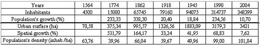
The first period corresponds to a tendency of a spatial concentration of the population around the commercial and administrative nucleus, as consequence of the urbanization process, fact illustrated in the reduced surface of the city (71 ha) and the high population's density (63,75 inhab./ha). The capital status accelerates the demographical (233,33%) and spatial (531,79 %) growth between 1564-1774. The spontaneous limits' expansion, supplied by a very active and uncontrolled immigration, overpasses in rhythm and scope the population's growth, fact visible in the low population density. Between1774 - 1862, when Iasi becomes a real economic and cultural metropolis, the demographical growth accelerates (338,3%), generating an improvement of the population's density (66,03inhab/ha). The lost of capital status (1862) reflects on the decreasing of the demographical and spatial evolution's rhythm, gradually improved after 1918 (the lower values of the population growth and density are the consequence of the two world wars and of the Iasi attractiveness decline) when the authorities involve in a controlled limits' expanding. The controlled spatial growth reaches its maximum during the socialist period. The systematisation urban plans and the significant population tides attracted by the industrialization process determine a very important demographical (234,55%) and territorial (68,83%) growth, and also an improvement in the built space's density and in the city's shape (more homogeneous). After 1990 the economic transition's effects are mirrored in a decreasing rhythm of the demographical (10,69%) and spatial (7,62%) evolution and in the lack of the authorities' control on the chaotic territorial expanding of the city.
Trends in the actual spatial evolution of Iasi. The most important trend shaped in the spatial evolution of Iasi is the periurbanization. The city's limits expand rapidly along the communication axes, as a consequence of focusing complex and selective demographical tides. These are at the basis of new districts well individualized by the socio - professional structure, the architecture and the urban aspects: luxurious villa districts, situated along the principal roads, on high quality terrains (Miroslava, Valea Adanca, Iezareni, Paun, Pietraria, Valea Lupului). The low outcomes population goes to the semirural marginal districts, lacking urban utilities and situated on unfavorable terrains (Manta Rosie, Pacuret, Obreja - Sapte Oameni, Crucea Rosie, Bogdan, Brandusa, etc.). The urban limits' growth is also based on the proliferation of the commercial units at the city's outskirts, along the communication axes: oil stations, commercial storehouses, auto showroom, etc.
There are not stagnating urban limits but only temporary stagnating outskirts, determined by natural (forests, sharp slopes) or administrative barriers, surpassed in time by the new dwellings: Poieni, the road to Hlincea.
The new residential outskirt tends to link with the neighboring settlements, which suffer great demographical, functional, economic and future possible administrative transformations.
Simultaneously there is a growth of the built space density, as consequences of the immovable market's pressure, causing a maximal terrain exploitation (devised in very small plots). After the saturation of the immovable offer in the city's center, the new dwellings focus on the districts avoided until now (semirural districts and ethnic nucleus) where they determine an aesthetical and urban rehabilitation, by attracting new services and utilities. The urban constructions' density is augmented by the proliferation of the commercial units concentrated along the communication axes and then spread in the residential districts. The land pressure generates their tendency of a vertically expanding: more and more firms' headquarters occupy the superior floors of the new tall central buildings but also the underground spaces attractive by their centrality and lower rents. The majority of the industrial units are placed in the ancient industrial areas, usually in the buildings of the factories from which they separated. Only some mobile industries (textile) spread over the residential areas and the technological park in construction (in the CUG zone) contribute at the built space's denseness.
Another important phenomenon for Iasi landscape's evolution is the progressive modification and diversification of the districts and roads' functionality, as consequences of the multiplication and the complexity of the demographical, material and informational tides inside the urban territory. The central buildings seem to loose step-by-step, their residential function (the flats are occupied by society headquarters), fact also met in all the residential districts, where the ground floor is transformed in commercial spaces. New commercial complex generate secondary commercial centers, changing also the functionality of their placement zone (educational function in Tudor Vladimirescu and transport function in Billa's area). The industrial zones usually maintain their functional specialization, but there are also phenomena as the placement of some little private university's classrooms in ancient industrial buildings, or the textile industries occupying ancient commercial spaces at the residential buildings' ground floor. In the outskirts there is a spontaneous concentration of the commercial storehouses, workshops, oil-stations, etc.
More and more visible is a tendency of a socio - professional, architectural and urban segregation of the city's territory. Opposing to the spatial uniformity politics of the communist regime, nowadays the heterogeneity of the urban space (caused by the diversity of the natural environment and by the succession of different territorial and economic politics) is supported by some factors as: the reduced degree of urban transports' fluidity and spatial efficacy, determined by the quality of the inherited infrastructure, the slow adaptation to the market economy and the un-loyal competition maintained by the partial attitude of the local authorities. There is a growth of the links with the neighboring settlements, encouraging the periurbanization phenomenon. The technical, urban, and socio - economic utilities represent another differentiation factor on the Iasi landscape, which puts together workers districts well endowed in urban utilities, semi-rural areas lacking urban facilities and villas zones disposing of all the modern utilities.
The communist politic of an exaggerate spatial planning generated some mental barriers, superposed on the districts limits, the roads or around urban major signs (squares, churches, commercial complex, etc.). Inside these invisible limits people knew each other by working in the same domain, having the same life style, frequenting the same stores, schools etc. After 1990, there is a socio - professional and functional diversification of the district's population based as consequence of the Iasi industrial restructuring and the multiplication of the material and informational urban tides. The limits are replaced by new ones created by the spontaneous regrouping of the population by outcomes and life style (fact stimulated by the immovable market and the opening to the western life style models). There for the city's landscape reunites bidonville zones in the Bahlui flood plain, the first gated communities in Bucium, modern villas districts, semi-rural areas and ethnic nucleus.
The latest years' spatial growth impose the necessity of a immediate intervention of the local authorities by elaborating efficient urbanization plans for the expanding zones, depending on the local natural and human particularities and the technical and urban utilities requested by the new districts. The socio-economic and politico-administrative evolution of Iasi has deeply marked the urban landscape, forced to successive restructurings and adjustments. There for the nowadays city is characterized by a striking socio-cultural and physiognomical eclecticism. The city' landscape juxtaposes different ages, cultural ethnic and social contrasts, all competing to create the image of a city which, hesitating between the past and the present, tries to build his own personality.
Literatura
1. Andronic A. Iasii pana la mijlocul secolului al XVII.-Iasi, 1986.
2. Cihodaru C., Platon Gh. Istoria orasului Iasi. Volum I.-Iasi, 1980.
3. Geografia Municipiului Iasi.-Iasi, 1987.
4. Pettrov E. Din evolutia urbanistica a orasului Iasi.-Iasi, 1936.
5. Ungureanu A. Evolutia teritoriala a oraselor din Moldova. An. UAIC, T XXII.-Iasi, 1976.
6. Ungureanu A. Orasele din Moldova. Studiu de geografie economica.-Buscuresti, 1980.