The Baseu Basin situated in the North-Eastern Romania represents a part of the Moldavian Plateau covering 964 km2 and stretching along 106 km.
Regarding the geological view point this basin covers the Moldavian Platform Unit (which is included in the East-Europen Platform) that is why the deposits and the land surface features are somehow monotoneus. This situation determines the difficulty of separating the landscape's units and sub-units on the basis of visual criteria. Consequently, in order to solve this problem, detailed anlayses on components were performed.
The consacrated literature is abundent in specific terminology, principles and methods of landscape units and sub-units identification. Generally speaking, French geographers, conceive the, paysage as a visual aspect.
In order to strengthen this aspect, the Anglo-Saxon vocabulary prefers the term scenary instead of landscape.
A close meaning both to the Anglo-Saxon term as well as to the Dutch term is the German word "Landschaft" which also covers the notions for teritory and sight. As far as the Russian origin terms "mesnost" and "urociste" are concerned, they have close teritorial value to the Germanic "Landschaft", from where it was borrowed, but because it received a scientific connotation its meaning was a little bit deviated from the initial word and more deviated in comparison with the French term "paysage".
Generally, the relief, the climate, the soil and the human intervention represents the landschaft [6]. Descending up to component level of the landscape, Baize [1] considers the "pedologic landscape" as being the correspondent of a cartographic unit, as long as it can be drawn at the selected scale. By not ignoring the human involvement in the modification of the natural environment, the author uses the phrase "rural landscape" which shows "the interaction between man and natural environment in time".
Methods. For the division of the landscape units and sub-units within the Baseu
hydrographic basin we have used: the morphometric detail analysis of the relief with the help of GIS thechniques; the analysis of the changes within the pedologic cover for the replacement of forest vegetation with secondary vegetation (pastures or cultivated vegetation); sin-ecologic analyses of ecological spectres and eco-diagrames for the represenatative associations of each landscape unit; analysis of the xerophile associations in the inferior part of the basin which should confirm the direct connection between natural vegetation and the characteristics of the environment or should demonstrate its secondary characteristic.
The relief altitudes are comprised between 60 m, at the confluence of Baseu River with the Prut River and 311 m in the Forest of Cristinesti Hill. Between these values, three quarters of the relief belong to the low hill type relief corresponding to the High Plain of Moldova and one quarter of the relief is a high hill type, corresponding to the Suceava Plateau.
The overall monoclinic structure of the unit on which the hydrographic basin is installed causes the organisation of the hydrographic network in a dendritic type having a north-west, south-east orientation.
The collector (the Baseu River) and its main tributary (Podriga creek) oriented according to the structure, have an important role in generating the hill type relief with long interfluves on NV-SE direction. This fact causes the slopes orientation to be mostly NE (33.4%) - SV (22.4%). The subsequent inferior order tributaries development, in the north-western compartment of the basin make the landscape various by modelating the cuesta type relief. This is characterised by the presence of the cuesta front slopes with declivities of 15-250 and over 250, occupying 32% of the basin surface and being affected by lanslides here the herbaceous and forest vegetation grows. The opposite cuesta slopes with 3-70 declivities are used for agriculture.
The statistical analysis of the main climatic parameters from three meteorological stations (Darabani in the north, Avrameni in the central part having over 30 years of activity and Stefanesti in the south) show Baltic climate influences in the north of the basin and eastern-European influences in the south. The climatic differences are shown by the annual average temperature values of 8.10C in the north of the basin (at Darabani 1987-1997) and 90C in the south (1985-1997) and the annual average precipitations which decrease from 571.6 mm (Darabani) to 456.3mm (Stefanesti). The higher altitudes in the north of the basin and the more rigurous climatic characteristics favourable for the forest vegetation allowed the division of the two landscape units: the unit of Ibanesti Hill (A) and the low hill unit (B) (fig. 1).
As far as the phito-cenology is concerned, unit A belongs to the nemoral zone- which includes the mesophyl oaks and the mixed evergreen oks-common oks and the nemoral (the sub-level of evergreen oaks and mixed forest)
Unit B belongs to the nortehrn silva-speppe with meso-phyl oak forest [4, Cristea, 1993].
The Unit of Ibanesti Hill (A) corresponds to the north-western compartment of Baseu basin. Within this unit, the geographical landscape is made up of narrow interfluves, structure oriented, alternating with fragments of structural plateau situated at 280-300 m and preserved because of the presence of gritstones. The slopes are modelated by landslides and suffered a spectacular retreat, probably during an interglacial age on the base of a more sandy ground [7]. In these conditions an excessive enlargement of the "U" type transversal valleys has been achieved, being often swampy and having a river bottom which is hardly noticeable.
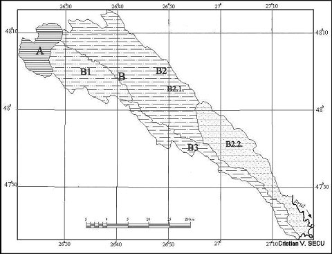
Fig. 1. Baseu River Basin. Landscape map.
A. The Unit of Ibanesti Hill B. The Low Hill Type Unit B 1. The Cuesta subunit B 2. The Subunit of the Low Hill Interfluves and of the Structure Oriented Valleys B 2.1. The north-western compartment B. 2.2. The south-eastern compartment B 3. The subunit of Baseu's right slope
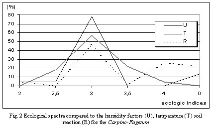
The Ibnesti Hiil is covered with mixed forest consisiting Fagus sylvatica and Carpinus betulus (which are co-dominant) and other essences: Quercus petraea, Tilia cordata, Acer campestre. The cenosis belong to Carpino-Fagetum association Pauc 41 and are characterized by two strata of trees, one stratum of medium-less evolved shrubs and one stratum of herbaceous vegetation, also medium-less developed. The ecologic spectres depending on the humidity factors, temperature and soil reaction (fig. 2) show the percentage of mesophyllus, meso-thermic and neutro-acidophil.
The Low Hill Type Unit (B), occupies most of the Baseu basin surface, comprising three subunits of natural-geographic landscapes with distinct features.
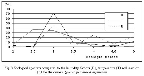
The vegetal cover of this subunit conists in cenosis of Querco petraeae-Carpinetum (Soo et Pocs 57) which mingels with natural pastures strongly affected by steppe instalation (with numerous pontic elements).
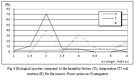
The mixed evergreen-hornbeam forest can be separated in three strata, with numerous representative species for each of them. The sinecologic anlysis shows the percent of the main ecologic categories (fig. 3). After the clear-cutting in this area plants like Rumex acetosella and Agrostis tenuis(Rumici-Agrostetum tenuis association Sanda et Popescu 81) or shrubs of Prunus spinosa and Crataegus monogyna (as. Pruno spinosae-Crataegetum (Soo 27) Hueck 31) that can preced evergreen oaks reappearance [4]. The ecologic features of shurb cenosis are illustrated by the specters in fig. 4.
The Cuesta subunit (B1) includes the subsequent sector of the Baseu River and the water flows (Ciolacul and Balinti creeks) with the same orientation situated in the south.
The dominant characteristic of the landscape is given by the cuestas slopes' asimmetry.
The Subunit of the Low Hill Interfluves and of the Structure Oriented Valleys (B2) is represented by the left hand side slope of Baseu basin. Within this subunit a north western and a south-eastern compartment have been divided by the inferior course of Bodeasa valley.
The north-western compartment (B2.1.) is characterised by the parallel feature of the Baseu, Podriga and partially Bodeasa consistent valley sections. Between these there are the extended structure oriented interfluves, separated by short subsequent valleys.
The south-eastern Compartment (B2.2.) presents just like the previous one, valleys with NNW-SSE orientation and often even N-S orientation. Their slopes are shaped by the wave form landslides, with thick accumulations, in settling stage, on which there are suspen-
ded ponds or sometimes even small lakes formed by landslides. At the level of the interfluves there are preserved few forest fragments, which in the past were largely extended, aspect that is confirmed by the study of the soils in the area.
Descending on the scale of the characteristics of landscape detailing we have identified the changes in the pedological cover by analysing two soil samples situated under the forest and cultivated vegetation.
Besides the geographic elements which are the main characteristic of the landscape we have analysed the features of two close soil samples but situated under forest and herbaceous vegetation it has been found that it has developed for a long while in stable environment conditions and, especially, under the same type of vegetation (forest vegetation). In these conditions, the pedogenetic illuvial and eluvial processes caused the differentiation of the soil types, aspect which is confirmed by the laboratory granulometric tests (El/Bt =30,48% si Bt1=34,88%). The soil under the cultivated vegetation is characterised by a divergent evolution, in the sense that the inferior part of the profile preserves physical-chemical features which resemble the one situated under the forest, and aso a series of neo-formations resulted from the degradation of the herbaceous vegetation roots. The upper part of the profile is marked by an accelerated mineralisation of the organic matter, by a more active removal of the nutritional elements and carbonates.
The soil under the forest was named luvosol according to the Romanian Taxonomy System of Soils [5] and luvisol according to WRB-SR [3], and the one situated under the herbaceous vegetation is called faeziom greic [5] or phaeziom [3].
To conclude, further to the human intervention in the landscape, the soil under the cultivated vegetation suffers a "regressive pedogenetic evolution" after a stage of "progressive pedogenesis"[2].
The subunit of Baseu's right slope (B3) appears in the form of a prolonged cuesta front slope that have been progeresively attaked by a simple hidrographic river net flowing directly to Baseu. In fact, the relief is much more complex enhacing an inclined interfluve
at the upper part that goes from 250 to 180 m; the medium part of this interfluve is affected by monticular "extiguishe" land slides [9] called "glimeeic land slides" [8] which have created a disoriented drainage net; at the lower part there are conserved to terraces (of 10 and 60 m relative altitude) and the river's meadow which was partially transformed by draining activities.
The figure below presents the eco-diagrams for the typical associations of the above mentioned categories.
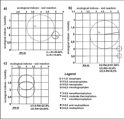
Fig. 5 Eco-diagrames for the associations: a) Taraxaco serotinae-Festucetum valesiacae b) Lolio-Plantaginetum majoris and c) Artemisio austriacae-Poetum bulbosae
The dominant herbaceus vegetation in B2.2 and B3 consists in:
1. Xerophilous and xero-mesophilous associations with plenty of pontic and mediteranean elements on soils with scarce nutritive components, suffering from erosion (Taraxaco serotinae-Festucetum valesiacae Sarbu, Coldea et Chifu 99, Medicagini-Festucetum valesiacae Wagner 41, Jurineo arachnoideae-Stipetum lessingianae Chifu et Sarbu 99, Taraxaco serotinae-Botriochloetum ischaemi Sarbu, Coldea et Chifu 99);
2. Mesophyllous and meso-hygrophlous associations along river valleys (Poetum pratensis, Ravarut at all. 56, Agropyretum repentis Burduja et all 56, Lolio-Plantaginetum majoris (Linkola 21) Beger 30;
3. Slated land associations on alkalinised soils (Artemisio austriacae-Poetum bulbosae Pop 70, Puccinellietum distantis Soo 39).
Conclusions. The analyis of this geographic landscape resulted in the separation of unit A, tipically a hill region, with dominant vegetation represented by the Carpino-Fagetum association and unit B, which is predominant in the Baseu river basin and consists in three different sub-units. The transition to the B unit and on interfluves the vegetation represented by Querco petraeae-Carpinetum forest, far more extended in the past as the morphologic cahracteristics of the solis confirmed. The B2.2 and B 3. sub-units are edified by xerophilous and xero-mesophylluos herbaceous associations as a result of east-european climatic influences.
Literatura
Baize D. Petits regions naturelles et paysages pedologiques de l'Yonne// INRA. Paris, 1993.
Birkeland P. W. Soil and geomorphology. New York, 1999.
Deckers J. A., Nachtergaele F. O., Spaargaren O. C. World Reference Base for Soil Resources. Leuven, 1998.
Donita N., Ivan D., Coldea Gh., Sanda V., Popescu A., Chifu Th., Pauca-Comanescu M., Mititelu D., Boscaiu N. The Romanian vegetation. Bucuresti, 1992.
Florea N., Munteanu I. The Romanian Soil System Taxonomy. Bucuresti, 2003.
Radulescu N., Ilie I. The Landschat Concept in SSUR // ARS, vol. XIV, s-III, 4, Bucuresti, 1960.
Rusu C., Margarint C. M., Secu C., Lesenciuc D., Rusu E. The Soil Cover Receptor and Indicator of Landscape Dynamics // Dynamics of the Geographic Landscape in Podisul Moldovei.
Tufescu V. Natural Modification of the Relief and the Accelerated Erosion. Bucuresti, 1966.
Zaruba, Q., Mencl, V. Land Slides and their Stability. Bucuresti, 1969.